
Mount Rainier National Park Overview
Visible from Seattle, the 14,410′ tall Mount Rainier National Park showcases some of the best hiking trails in the Pacific Northwest. Below the highest point in Washington are valleys, waterfalls, meadows, and old-growth forests that house the park’s abundant wildlife population. Visitors to Mount Rainier National Park are likely to encounter mountain goats, marmots, deer, and possibly elk as they set out on hikes across the base of the mountain. The park can get crowded during the summer months so it is best to plan ahead and know where you’d like to go. Most visitors come from either the south Nisqually entrance or the east White River entrance before heading to the popular Sunrise Visitor Center. Below are the 9 best day hikes in Mount Rainier National Park for your enjoyment!
| State | Washington |
| Nearest Metro Area | Seattle, WA |
| Area Size | 236,381 acres |
| Established | March 2, 1899 |
| Hiking Trails | 260 miles |

Thoughtful designs inspired by America’s National Parks.
The National Park Series — custom designs drawn from the landscape.
Trailhead Traveler’s Recommended Best Hikes in Mount Rainier National Park
Skyline Loop (Paradise)

This is one of the most crowded hikes in the park but definitely one that you’re not going to want to miss. The loop isn’t easy by any means but you’ll catch some of the best and closest views of Mount Rainier in the entire park. Along the way you pass Panorama Point, Myrtle Falls, and Sluiskin Falls. The trailhead is located near the entrance to the Jackson Visitor Center at Paradise, marked by stone steps inscribed with a quote by John Muir. Considering this is one of the best hikes in Mount Rainier National Park, the trail can be crowded throughout the week.
- 5.5 mile loop
- 1,700′ elevation gain
- Strenuous
Mt. Fremont Lookout Trail (Sunrise)

Follow the Sourdough Ridge Trail to the junction at Frozen Lake, then take the Mount Fremont Trail to the old fire lookout with a great view of the North side of Mount Rainier. The trailhead is located at Sunrise – follow the Sourdough Ridge trail west to the five way trail intersection at Frozen Lake; then take the Mount Fremont trail along a loose, rocky ridge.
- 5.6 miles out and back
- 900′ elevation gain
- Moderate
Grove of the Patriarchs (Ohanapecosh)

This is a short and easy hike but one that you’ll be glad that you did – the trail travels through an old-growth forest with some of the oldest and tallest trees in the world. The trailhead is located at a parking location on Stevens Canyon Road just Northwest of the Stevens Canyon Entrance Station.
- 1.2 miles out and back
- 100′ elevation gain
- Easy
Comet Falls Trail (Longmire)

Mile for mile, this is one of the more challenging hikes in the entire park. The trail ascends nearly 2 miles to aptly-named 320′ Comet Falls. You can continue the trail once to get to Comet Falls to Trump Park (steep snow slopes well into summer months). The trailhead is located in a parking area on Paradise Valley Road between Longmire and Paradise.
- 3.8 miles out and back
- 900′ elevation gain (2200′ to Trump Park)
- Strenuous
Trail of the Shadows (Longmire)

Self-guiding loop that takes you through the area’s history. The trailhead is located across from the Longmire Museum.
- 0.7 mile loop
- No elevation gain
- Easy
Spray Park Trail (Mowich Lake)

Forested trail that leads to 300′ Spray Falls. The trailhead is located on the southeast side of Mowich Lake walk-in campground at the end of Mowich Lake Road.
- 6 miles out and back
- 1300′ elevation gain
- Moderate
Glacier Basin Trail (Sunrise)

This trail follows the White River for 3.5 miles to Glacier Basin Camp at 6,000′ on the North Side of Mount Rainier. The trailhead begins at the upper end of the White River campground.
- 7.0 miles out and back
- 1,280′ elevation gain
- Strenuous
High Lakes Loop (Paradise)
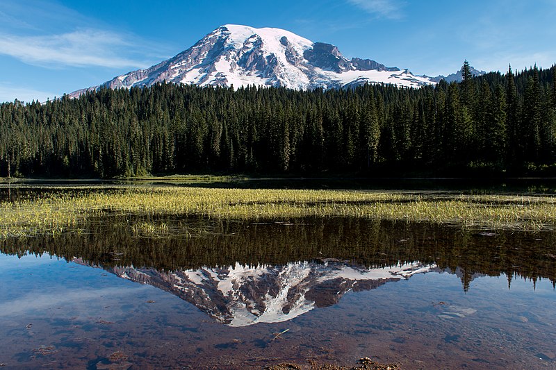
Hike around Reflection Lakes. The trailhead is located at the Reflection Lakes parking area on the North side of Stevens Canyon Road.
- 5.0 mile loop
- 1300′ elevation gain
- Moderate
Nisqually Vista Trail (Paradise)

Paved loop with great views of the Nisqually Glacier. The trailhead is located at the stone steps near the Jackson Visitor Center.
- 1.0 mile loop
- 200′ elevation gain
- Easy
Bonus: Wonderland Trail

Although it is by no means a day hike, I felt like I had to include The Wonderland Trail on the list. The 93 mile trail circumnavigates Mount Rainier and goes through forests, valleys, and high alpine areas.
- 93 mile loop
- 22,000′ elevation gain cumulatively
- Strenuous
Featured Image: Mount Rainier, Photo by Chris Haffler

Don’t forget to stock up on the essentials before you plan your next hiking or camping trip! We have recommendations on:
TENTS
HIKING BOOTS
AND MORE!
Sandra
Thanks for posting this content. Quick and succinct guide to hikes in Washington. Will use this info on future planned trips to the region. Keep up the good work!