
Gros Morne National Park Overview
Gros Morne National Park is located on the western coast of Newfoundland and Canada’s 2nd most easterly national park. In addition to being a Canadian national park, Gros Morne is also a World Heritage Site. The name Gros Morne recalls a time when the French fished along this coast. “Gros” means big, “Morne” is a Creole word for a small, rounded mountain standing alone. The park’s Long Range Mountains form the northernmost section of the Appalachian mountains, stretching along the island’s entire west coast. Many hikers are drawn to the park to backpack the 35km Long Range Traverse. That hike and the other best hikes in Gros Morne National Park are described below.
| Location | Newfoundland and Labrador, Canada |
| Nearest Metro Area | St. John’s, Newfoundland and Labrador |
| Area Size | 446,025 acre |
| Established | 1973 |
| Hiking Trails | 74 miles |

Thoughtful designs inspired by America’s National Parks.
The National Park Series — custom designs drawn from the landscape.
Trailhead Traveler’s Recommended Best Hikes in Gros Morne National Park
Gros Morne Mountain Trail

If time is limited and you can only complete one of the best hikes in Gros Morne National Park, the hike to the summit of Gros Morne Mountain is a must.
Follow the path to Gros Morne National Park’s highest point (806m). Your efforts will be rewarded by breathtaking views of the Long Range Mountains and the Ten Mile Pond gorge. The flat summit is a harsh yet beautiful Arctic-alpine environment, home to arctic hare, rock ptarmigan, and arctic-alpine plants. The first 4.5km of trail winds through forest to a viewing platform at the mountain base. You’ll find frequent stairs and boardwalk—and enjoy views of Bonne Bay, the Tablelands, and Gros Morne Mountain. For a half-day hike, simply return by the same route. The more challenging mountain section of the trail starts at the viewing platform. It’s an 8km loop that takes you up almost 500m to the arctic-alpine plateau, then descends as a rough boulder-strewn path through Ferry Gulch. *The mountain is closed to hikers in May and June.
- 10.6 miles (17km) out and back
- 3,280’ (1,000m) elevation gain
- Strenuous
Long Range Traverse

The Long Range Traverse is an unmarked and rugged backcountry route. Of all the best hikes in Gros Morne National park, this is the one that draws the most attention and for good reason. It starts from Western Brook Pond, leads onto the Long Range Mountains and south towards Gros Morne Mountain before descending into Ferry Gulch and returning to highway 430 by way of the Gros Morne Mountain trail. Along the way a series of five campsites provide waypoints that help define the route. The ascent onto the Long Range mountains through Western Brook Pond gorge is the most strenuous and possibly the most spectacular part of the entire route.
- 21.7 miles (35km) one-way
- 4,000’ (1,220m) elevation gain
- Strenuous
Western Brook Pond

Follow the trail to the shores of Western Brook Pond and its impressive backdrop of spectacular cliffs and the Long Range Mountains. Along the way you’ll cross the bogs and forested ridges of the parks’ coastal lowlands. Look for interpretive signs that explain some of the area’s natural features. In addition to the hike, boat tours of Western Brook Pond are popular. On board, behold the spectacular glacier-carved land-locked fjord, waterfalls cascading from 2000 feet that often turn to mist before reaching the pond, billion year-old cliffs, and frequent wildlife sightings.
- 3.7 miles (6km) out and back
- 115’ (35m) elevation gain
- Easy
Baker’s Brooks Falls Trail

The trail leads you through balsam fir forest to Bakers Brook Falls, a series of cascades over limestone ridges. The forest is in several stages of regeneration, recovering from the natural effects of winds and insects. Heavy moose browsing has limited its regrowth in many places.
- 5.7 miles (9.2km) out and back
- 425’ (130m) elevation gain
- Moderate
Tablelands Trail
The main trail follows an old roadbed as it skirts the base of the mountain. You will see unusual plants and rocks as you enjoy broad panoramic views. The trail ends in the glacially carved Winter House Brook Canyon. For a shorter walk, branch off onto the Serpentine Loop, where you will see characteristic plants of the Tablelands alongside a winding path. Geology here marks a time when the continents of Africa and North America collided, pushing these rocks, originally beneath the ocean, to their present position on land.
- 2.5 miles (4km) out and back
- 770’ (235m) elevation gain
- Moderate
Green Gardens Trail

Follow the trail to a spectacular coastline of cliffs, sea stacks, and the meadows of Green Gardens. You’ll cross serpentine barrens, descend through forest, and reach the shore at Old Man Cove. Continue north along coastal headlands and meadows, or take the stairs to a beach with waterfalls and a sea cave.
- 5.6 miles (9km) out and back
- 920’ (280m) elevation gain
- Moderate
Lookout Hills Trail

Follow the trail to one of the best panoramic vistas in the park. You’ll climb steadily through forest, then emerge from the trees onto a highland plateau. From the platform atop Partridgeberry Hill, you’ll enjoy spectacular views of Bonne Bay, Gros Morne Mountain, the Tablelands, and the Lookout Hills. The trailhead starts in the Discovery Centre parking lot located in Woody Point on route 431.
- 3.1 miles (5km) out and back
- 1,330’ (405m) elevation gain
- Moderate
Coastal Trail

The path once connected two small fishing communities: Bakers Brook and Green Point. It leads you by cobble beaches and through short but dense coastal forests known locally as “tuckamore.” It’s a perfect trail for enjoying coastal landscapes, ocean breezes, and views of the setting sun. Tuckamore is the Newfoundland word for the stunted trees that grow along the coast and in alpine areas. Frost and wind nip back the trees’ exposed branches, giving them their wind-swept profile.
- 3.7 miles (6km) out and back
- 33’ (10m) elevation gain
- Easy
Lobster Cove Head

Wander the headland and follow the trail through tuckamore forest down to the shore. One of the most popular locations in the park to watch the sunset. The rocky beach with its tidal pools is excellent for exploring at low tide. The lightkeeper’s house is open to visitors from mid May to mid October and contains an exhibit about the history of the area.
- 1.2 miles (2km) out and back
- 65’ (20m) elevation gain
- Easy
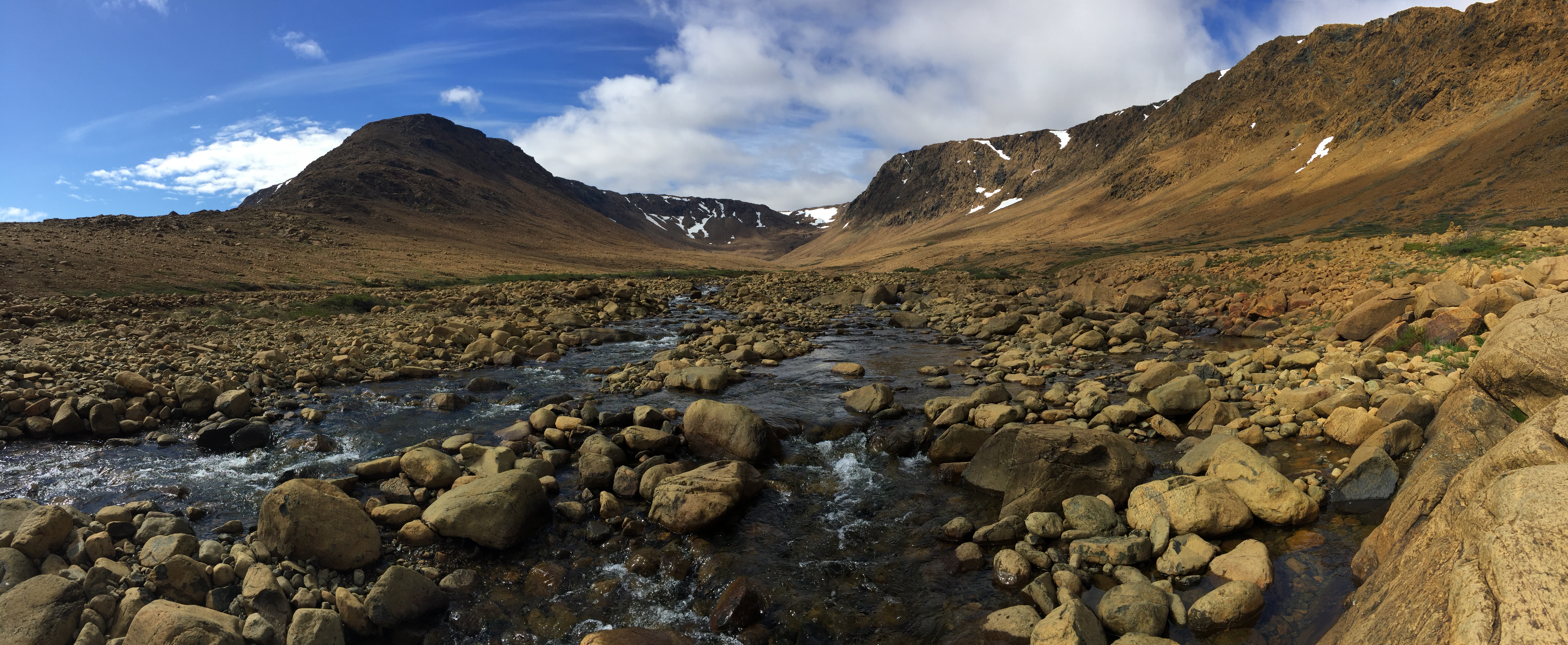
Featured Image: National Park Gros Morne Newfoundland, Photo Michel Rathwell

Don’t forget to stock up on the essentials before you plan your next hiking or camping trip! We have recommendations on:
TENTS
HIKING BOOTS
AND MORE!