
Daniel Boone National Forest Overview
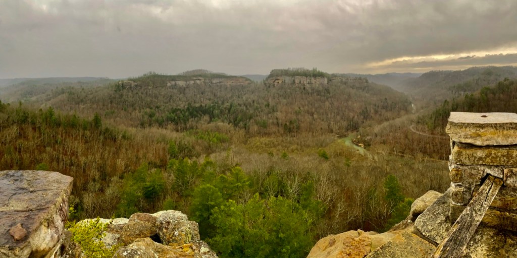
The Daniel Boone National Forest extends across the western plateau region of the Appalachian Mountains in beautiful eastern Kentucky. Originally named the Cumberland National Forest, the forest was renamed in 1966 in recognition of the adventurous frontiersman that explored much of this Kentucky region. The most popular area for hiking is the Red River Gorge Geological Area within the Cumberland Ranger District of the forest. The Gorge boasts breathtaking scenery and unique geological features, including hundreds of sandstone arches and miles of towering cliffs that attract rock climbers from around the world. When hitting the trails, be sure to plan ahead and look at a map of the area beforehand; many of the hikes combine trails or can be extended into a loop with an added destination rather than just an out and back. The best hikes in Daniel Boone National Forest are described below.
| State | Kentucky |
| Nearest Metro Area | Lexington, KY |
| Area Size | 709,000 acres |
| Established | February 23, 1937 |
| Hiking Trails | 600 miles |

Thoughtful designs inspired by America’s National Parks.
The National Park Series — custom designs drawn from the landscape.
Trailhead Traveler’s Recommended Best Hikes in Daniel Boone National Forest
(*** = Best hikes in Daniel Boone National Forest)
Auxier Ridge Trail #204 + Double Arch Trail #201*** – 6.2 mile loop

This loop is a combination of multiple trails so be sure to plan ahead. Hikers can start in either direction but to avoid the most elevation gain, it is recommended to go counter-clockwise. Auxier Ridge Trail follows a high, narrow ridge 2.1 miles to its end where views of Double Arch, Haystack Rock, Courthouse Rock, Raven Rock and other views of the Red River Gorge are numerous. Sheer cliffs extend on both sides of the ridge. Auxier Branch Trail #203 connects #201 and #204. The trail leaves Double Arch and extends through a wooded canyon to the base of Courthouse Rock. Double Arch Trail #201 descends below a high sandstone cliff and through a forest of giant hemlocks and bigleaf magnolias. At the end of the ridge, a breathtaking overlook sits underneath Double Arch.
Bark Camp Trail #413 – 5.2 miles out and back

This trail follows the north side of Bark Camp Creek. The trail passes under rock shelters and cliffs. There is a small waterfall about a mile from the trailhead and a beautiful series of cascades near the trail’s junction with the Sheltowee Trace National Recreation Trail. An Adirondack shelter is located on the Sheltowee Trace about one tenth mile south of its junction with Bark Camp Trail. The creek is stocked with rainbow trout.
Chimney Top Trail #235 + Princess Arch Trail #233 – 1.0 miles out and back
These hikes are actually 2 separate 1/2 mile out and back hikes starting from the same parking area. Chimney Top Trail #235 passes through pine-hardwood forest to a breathtaking overlook on Chimney Top Rock. The Red River flows in the gorge below the overlook. Half Moon Rock is nearby to the left. Princess Arch Trail #233 extends along a dry wooded ridge to the scenic Princess Arch.
Dog Slaughter Falls Trail #414 – 7.5 miles out and back

Dog Slaughter Falls Trail on London Ranger District runs parallel to Dog Slaughter Creek through dense stands of hemlock and rhododendron. Near the mouth of the creek, a 15-foot waterfall (Dog Slaughter Falls) provides a scenic place to enjoy nature. The trail meanders over and around massive boulders before it connects to Sheltowee National Recreation Trail #100. The trail ends at the Cumberland River.
Grays Arch Trail #205 + Hanson’s Point*** – 6.7 mile loop

Grays Arch Trail #205 begins at the Grays Arch Picnic Area off of Tunnel Ridge Road. After 1/4-mile, the trail follows Rough Trail #221 down the ridge and then off into a drain to King Branch. The trail again forks, continuing to Grays Arch. The trail is scenic and rich in native flora. During wet weather, a beautiful waterfall occurs at the arch. Continuing on Rough Trail #221 before you reach the junction with Pinch’em Tight Trail, an unmarked trail heads north for .8 miles to Hanson’s Point. This overlook provides a great view of Pinch’em Tight, Chimney Top Rock, and Half Moon across the gorge below. Head back to the trailhead via Pinch’em Tight Trail #223.
Indian Staircase*** – 3.5 mile loop

This hike requires some difficult rock scrambles and navigation skills as it accesses several unmarked trail but is one of the best hikes in the Red River Gorge Area. Begin on Bison Way Trail #210 until it intersects with Sheltowee Trace Trail. After that you will take a right on an unmarked trail before climbing up Indian Staircase. Next, you will make your way back to Sheltowee Trace Trail to locate Indian Arch. Hikers can return to the Bison Way Trailhead or continue on to find another unmarked trail to access ‘Cloudsplitter’. This super fun hike provides incredible views after another difficult rock scramble. As mentioned previously, it is imperative to come prepared when locating these unmarked trails as they are easy to miss.
Natural Bridge*** – 3.0 mile loop

Begin on the Sheltowee Trace Trail off of Natural Bridge Road on this extremely popular family-friendly trail. After a steady climb of approximately 3/4 of a mile, hikers will squeeze through Fat Man’s Squeeze before climbing on top of Natural Bridge with amazing views of the surrounding area. After taking in the sights, you can loop back to the trailhead via Balanced Rock Trail or continue onto Laurel Ridge Trail from atop the bridge for an extended experience. Laurel Ridge Trail is mainly flat and will take you to spectacular viewpoints at Lookout Point and Lover’s Leap, 0.75 miles from Natural Bridge.
Rock Bridge Trail #207 + Swift Camp Creek Trail #219 – 4.2 mile loop

Rock Bridge Trail #207 is a loop trail that descends into a deep ravine with towering hemlock trees and dense rhododendron understory. Begin at the trailhead on the south side of the picnic area. Hikers enjoy the tranquil setting near Rock Bridge, a natural standstone arch that spans across the creek. This arch is the only “bridge” in the Red River Gorge over water. A small waterfall upstream provides an ideal spot for some quiet time with nature. After Rock Bridge, turn right onto Swift Camp Creek Trail for a little over a mile before taking an unmarked trail left to find Turtle Back Arch. The trail following Turtle Back Arch takes you back to Rock Bridge Road where you can walk the 0.9 miles back to the trailhead. With any unmarked trail in the area, be sure to plan ahead and bring a GPS tracker!
Sheltowee Trace Trail #100 Section 26 to Van Hook Falls – 5.4 miles out and back
Cane Creek is a popular fishing stream and destination for day hikers. Rock ledges along the creek provide scenic places to stop for a rest or to have lunch. Van Hook Falls is a 10-minute walk just north of the creek. The falls are at their best following the spring rains.
Sky Bridge Trail #214 – 0.8 mile loop

The hike, a semi-blacktop loop trail, leaves the Sky Bridge parking area and extends along a high narrow ridge to Sky Bridge and scenic overlooks. The trail passes over and beneath Sky Bridge, and then along a high cliff shelf back to the parking area. The main attractions are breathtaking overlooks into the Red River Gorge and the natural sandstone arch known as Sky Bridge.
Featured Image: Photo by Chris Haffler

Don’t forget to stock up on the essentials before you plan your next hiking or camping trip! We have recommendations on:
TENTS
HIKING BOOTS
AND MORE!