
This is the ultimate bucket-list countdown for any outdoor loving, hiking enthusiast, national park nut (like me)! I have spent about a year compiling all of the best national park hikes, hoping one day that I may get the chance to complete them all. Take a look below and see if your favorite hike made the cut. You can click on the name of the national park to see more of the best hikes in that park.
59. No Established Trails (Kobuk Valley National Park)
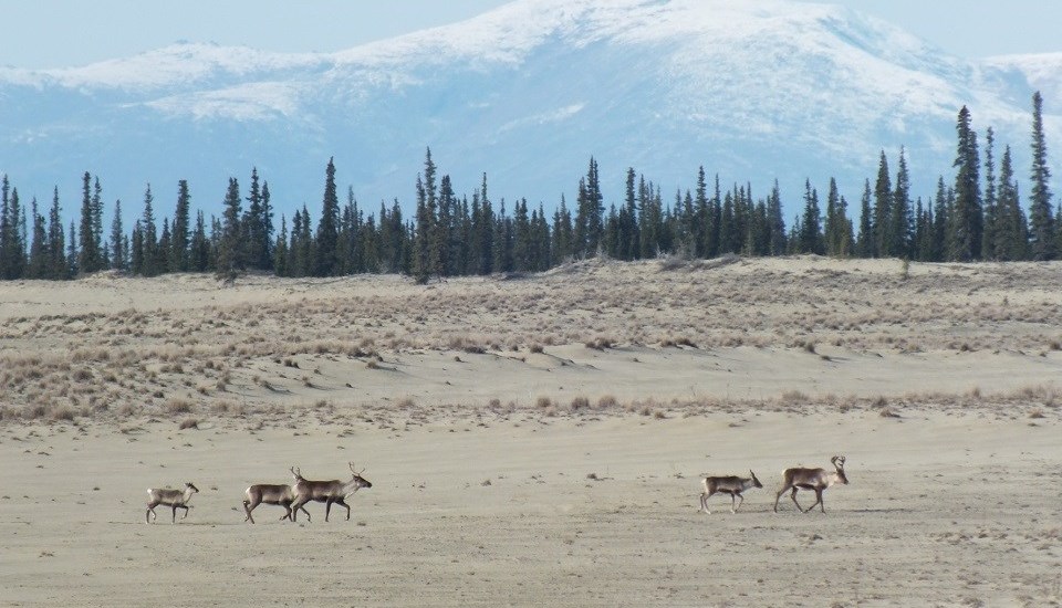 Backpacking is a great way to experience Kobuk Valley National Park but there are no established trails.
58. No Established Trails (Gates of the Arctic National Park and Preserve)
 There are no established trails visitors must backpack over dense vegetation and frequent river crossings to get to where they want to go.
57. Jetty Trail (Biscayne National Park)
 This is a short and easy walk along the mangrove-lined shore next to the Dante Fascell Visitor Center and leads to the Colonial Bird Protection Area. Half of the trail is boardwalk while the other half is a smooth sand/gravel surface. The trailhead can be accessed next to the Visitor Center about 30 miles south of Miami.
- 0.5 miles – Out and back
- No elevation gain
- Easy
56. Fort Jefferson Loop (Dry Tortugas National Park)
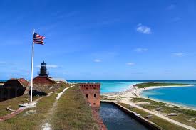 This is a self-guided 1/2 mile loop around one of the largest 19th century forts in the United States. The fort was built as an ‘advance post’ to monitor ships patrolling the Gulf of Mexico and Straits of Florida.
- 0.5 miles – Loop
- No elevation gain
- Easy
55. Petroglyph Point Trail (Mesa Verde National Park)
 Popular hike that you can take the family on before or after one of the many cliff tours of Mesa Verde. The panel of petroglyphs are about halfway along the trail. There is a bit of rock scrambling required and once back near the trailhead, hikers have the option of adding on the Spruce Canyon Trail. The trailhead can be found near the Chapin Mesa Archeological Museum.
- 2.4 miles – Loop
- 450′ gain
- Moderate
54. Boardwalk Loop (Congaree National Park)
 This elevated trail takes hikers on a self-guided loop around the Congaree Swamp. You’ll pass Weston Lake, an old channel of the Congaree River. The trailhead is located next to the Harry Hampton Visitor Center.
- 2.3 miles – Loop
- No elevation gain
- Easy
53. Forest Trail (Glacier Bay National Park)
 Leisurely loop through the temperate rainforest and beach area of Bartlett Cove. There are several viewing platforms along the way that will allow you to take in the surroundings. Ranger led guides leave at 1:30 pm daily. The trailhead can be accessed next to the Glacier Bay Lodge and Visitor Center.
- 1.1 mile – Loop
- 100′ gain
- Easy
52. Brooks Falls Trail (Katmai National Park and Preserve)
 This is the most popular trail in Katmai as you are almost certain to come face to face with brown bears. At the end of the trail, 2 raised platforms offer a great vantage point to watch bears fishing in the Brooks River. This is best in July during the salmon run. Exercise extreme caution! The trailhead begins across the vault toilets .3 miles from the Lower River Platform.
- 1.2 miles – Out and back
- No elevation gain
- Easy
51. Anhinga Trail (Everglades National Park)
 This is a short and easy trail that immerses hikers into the park’s beautiful and unique biodiversity. Along the way you’ll see alligators, turtles, birds and other forms of wildlife in their natural habitat. The trailhead is located next to the Royal Palm Visitor Center.
- 0.8 miles – Loop
- No elevation gain
- Easy
50. Green River Bluffs Trail (Mammoth Cave National Park)
 The trail begins near the River Styx Trail and winds its way along the Green River with some great views as you get to the riverside bluffs. The trailhead is located at the end of the 0.6 mile River Styx Trail near the Visitor Center.
- 1.3 miles – Loop
- 400′ gain
- Moderate
49. Hot Springs Mountain Loop (Hot Springs National Park)
 This mountain loop is a family friendly trail and one of the more scenic hikes in Hot Springs National Park. Be sure to stop at the Hot Springs Mountain Tower to gaze at the expansive views of the area. The trailhead is located at the pagoda shelter just south of Hot Springs Mountain Tower.
- 1.7 miles – Loop
- 200′ gain
- Easy
48. Blue Mesa Trail (Petrified Forest National Park)
 Short loop that descends from the mesa to an area of petrified wood and views of the surrounding badlands with blue infused clay that is incredible to see in person. The colors are especially spectacular to see after a recent rainfall. The trailhead is located next to the shelter on Blue Mesa Scenic Road.
- 1.0 miles – Loop
- No elevation gain
- Easy
47. High Peaks Loop (Pinnacles National Park)
 This is one of the quintessential hikes in California, not just one of the best hikes in Pinnacles National Park. A rocky and steep trail will get you to the high pinnacles that the park was named after. Along the way you will have gorgeous views of the surrounding area, pass amazing rock formations, and have a great chance of seeing the California Condor! The entire loop is a combination of High Peaks Trail, Condor Gulch Trail and Bear Gulch Trail. The trailhead can be accessed in the Bear Gulch Day Use Area.
- 5.3 miles – Loop
- 1400′ gain
- Strenuous
46. Ledges Trail (Cuyahoga Valley National Park)
 This scenic trail passes through sandstone cliffs known as Ritchie Ledges. Make sure you bring some sure-footed hiking boots as you’ll pass over rocky ground and a rock staircase. You can continue on the Pine Grove Trail to make the loop longer. The trailhead is located at the Ledges Parking Area off Kendall Park Road.
- 2.2 miles – Loop
- 100′ gain
- Easy
45. Smuggler’s Cove Trail (Channel Islands National Park)
 Santa Cruz is the largest island of this national park and Smuggler’s Cove is one of the most popular hikes in Channel Islands. The trail climbs steeply to the west side of the island and visitors have the chance to see all of the wildlife and nature that make these islands so great. If you can only do 1 hike on Santa Cruz, make it this trail. The trailhead starts from Scorpion Beach.
- 7.5 miles – Out and back
- 1400′ gain
- Strenuous
44. Ryan Mountain Trail (Joshua Tree National Park)
 Hike up the steep trail on the right side of Ryan Mountain to its summit. This may be a difficult trail but it’s one of the most popular hikes in Joshua Tree National Park. Once you are at the summit, enjoy some of the best views in the park before returning the way you came. The trailhead is located off of Park Blvd. near Sheep Pass and Ryan Campground.
- 2.9 miles – Out and back
- 1000′ gain
- Strenuous
43. Reef Bay Trail (Virgin Islands National Park)
 Starting from the middle of the island, hikers will travel downhill through a heavily forested area before reaching a secluded beach on the south side of St. John. Petroglyphs Trail makes for a nice bonus to view some ancient markings. The hike back up is quite a challenge, so be ready! The trailhead is located on Route 10 and is somewhat hard to find parking on the side of the small road.
- 4.8 miles – Out and back
- 900′ gain
- Moderate
42. Cruiser Lake Trail (Voyageurs National Park)
 This trail system crosses the Kabetogama Peninsula (north to south) which makes up a majority of the park. You’ll pass some beautiful inland lakes. Most visitors to the park are on the water so you’ll have the trail to yourself with a good chance of seeing a moose or deer. The trailhead is only accessible by boat and hikers can start either on the Kebetogama or Rainy Lake side.
- 9.5 miles – one way
- 200′ gain
- Moderate
41. Castle Trail (Badlands National Park)
 This is the longest trail in the park and can be used to access some of the park’s other trails to make an ‘ultra’ Badlands circuit hike. Most of the trail is through the prairie; on the way hikers can explore Saddle Pass, Medicine Root Trails as well. The trailhead is located next to the Fossil Exhibit Trail parking area or you can begin on the east side at the parking area for the Door and Window Trails.
- 10 miles – Out and back
- 400′ gain
- Moderate
40. Mount ‘Alava Trail (National Park of American Samoa)
 To reach the summit of Mount ‘Alava, you can either begin from Fagasa Pass or Vatia Village. I would recommend starting from Vatia as it is near Lower Sauma Ridge Trail and you are aided by steps. There are hundreds of steps and ladders to make the climb up to the summit.
- 7.2 miles (Fagasa Pass) / 5.6 miles (Vatia Village) – Out and back / Loop
- 1500′ gain
- Strenuous
39. Telescope Peak Trail (Death Valley National Park)
 Telescope Peak is the highest point in Death Valley National Park. At around 2 miles, the trail levels out at Arcane Meadows before following a narrow, winding ridge line to the summit. The trailhead starts at the Mahogany Flat Campground.
- 14.0 miles – Out and back
- 3000′ gain
- Strenuous
38. Lookout Point Trail (Wind Cave National Park)
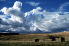 Traveling clockwise, the first 1.5 miles is shared with Centennial Trail. There is a lot of variety on this loop, from hills to stretching prairies; and a good chance of seeing bison roaming around. The trailhead is located at the same parking area as Centennial Trail off of the east side of SD-87.
- 4.5 miles – Loop
- 400′ gain
- Moderate
37. Stoll Trail (Isle Royale National Park)
 This trail winds its way between the forest and shoreline communities out to spectacular Scoville Point. You’ll pass craggy cliffs, harbor views, and ancient mines along the way. The trailhead is located next to the Rock Harbor Lodge.
- 4.2 miles – Loop
- 200′ gain
- Easy
36. Garfield Peak Trail (Crater Lake National Park)
 One of the most popular hikes in Crater Lake National Park, climbing steadily up to Garfield Peak. There are incredible panoramic views as you ascend the ridge and even more at the top. The trailhead is east of Rim Village, near the Visitor Center.
- 3.6 miles – Out and back
- 1000′ gain
- Strenuous
35. Kīlauea Iki Trail (Hawaii Volcanoes National Park)
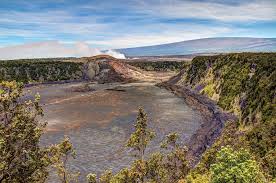 One of the best hikes in Hawai’i is this incredible trail that hikers can walk across a once-molten lake of lava in Kīlauea Iki Crater. The trail descends through a lush rainforest before Pu’u Pua’i cinder cone which was the main vent of the 1959 eruption. After walking across the solid lake surface, you will loop back near Thurston Lava Tube. This cave-like feature formed from the lava flow is definitely worth the short walk. The trailhead is located at a parking area on Crater Rim Drive.
- 4.0 miles – Loop
- 400′ gain
- Moderate
34. Rattlesnake Canyon Trail (Carlsbad Caverns National Park)
 Although there are not many hikes in Carlsbad Caverns National Park, this is one that you won’t want to miss if you’re interested in checking out the desert landscape. The trail descends into a side canyon before leading you to the larger Rattlesnake Canyon. There is an old homestead from the 1930s along the way as well. The trailhead is located on Desert Loop Road about 2 miles from the Visitor Center.
- 6.0 miles – Out and back
- 600′
- Moderate
33. Painted Canyon Loop (Theodore Roosevelt National Park)
 This is a steep but short trail that descends into the canyon that offers great views of the surrounding landscape. Great warmup trail to introduce you to the park. The trailhead is located at the Painted Canyon Visitor Center next to I-94.
- 1.1 miles – Loop
- 250′ gain
- Moderate
32. Tanalian Falls Trail (Lake Clark National Park and Preserve)
 This is the only maintained trail system in the park and preserve but it is a beauty. Tanalian Falls and Kontrashibuna Lake are both gorgeous spots that add majesty to this park. Hikers can take a clockwise path taking Beaver Pond Trail all the way to the lake before returning via Tanalian Falls Trail. The trailhead is located in Port Alsworth, AK near the Lake Clark National Park Visitor Center.
- 5.5 miles – Loop
- 800′ gain
- Moderate
31. Guadalupe Peak Trail (Guadalupe Mountains National Park)
 The hike up Guadalupe Peak will get you to the highest point in the state of Texas (8,749′). The long climb is a steady uphill the entire way with switchbacks throughout. Sign the summit register and enjoy the expansive views before beginning your return trip down the mountain. The trailhead is located near the Pine Springs Campground.
- 8.4 miles – Out and back
- 2900′ gain
- Strenuous
30. Mesa Arch Trail (Canyonlands National Park)
 While it is difficult to say that a 1/2 mile stroll is at the top of the best hikes in Canyonlands, no visit would be complete to this incredible park without seeing Mesa Arch up close. Mesa Arch is a spectacular low angle arch sitting on the edge of a cliff perfectly framing the vast geological canyons below. Sunrise is a very popular and crowded time to hike the trail because the sun rises perfectly behind the arch setting up the ultimate photo. The trailhead is located on Grand View Point Road near the Upheaval Dome junction.
- 0.5 miles – Loop
- 50′ gain
- Easy
29. Lassen Peak Trail (Lassen Volcanic National Park)
 Popular trail that travels steeply up to the summit of Lassen Peak, an active volcano. The summit is the highest peak in the park and the surrounding views are incredible. The trail is steep and rocky but still easily one of the best hikes in Lassen Volcanic National Park. The trailhead is located in a parking area off of Highway 89.
- 5.0 miles – Out and back
- 2000′ gain
- Strenuous
28. South Rim Loop (Big Bend National Park)
 If you include the 1.5 mile Emory Peak Trail, this 16+ mile loop makes for an awesome all-day adventure. Complete the loop either clock-wise via that steeper Pinnacles Trail or via the more gradual Laguna Meadow Trail. The breathtaking views at South Rim mark the halfway point. There are also plenty of backcountry camping sites along the way if you need to stop for the night. The trailhead is located at the Chisos Basin Visitor Center.
- 16.6 miles – Loop
- 3300′ gain
- Strenuous
27. King Canyon Trail (Saguaro National Park)
 A gradual climb through the rocky desert until you get to Sweetwater Trail junction where the trail steepens. Switchbacks for the last mile get you to the top of Wasson Peak (4687′). Head back via Hugh Norris and Sendero Esperanza to make a loop of the area. The trailhead is located off Kinney Road across from the Desert Museum.
- 8.4 miles – Loop
- 1750′ gain
- Strenuous
26. Root Glacier Trail (Wrangell–St. Elias National Park and Preserve)
 The way to Root Glacier crosses over Bonanza Creek and Jumbo Creek, then winds over the glacier’s lateral moraines. When you arrive at Root Glacier you can use crampons to carefully walk on the glacier. The area is gorgeous and this is probably the most popular of all the hikes in Wrangell – St. Elias. The trailhead can be found at Kennecott Mill Town.
- 4.4 miles – Out and back
- 500′ gain
- Easy
25. North Vista Trail (Black Canyon of the Gunnison National Park)
 If you add on the short spur trail to Exclamation Point on your way up to Green Mountain, this is easily the best hike in the park. The climb up to the summit is no job but you cant beat the views into the canyon. Another positive note of this trail is that it is rarely crowded, even in the summer months, so enjoy! The trailhead is next to the North Rim Ranger Station off of Black Canyon Road.
- 6.7 miles – Out and back
- 1200′ gain
- Strenuous
24. Bearfence Mountain Trail (Shenandoah National Park)
 Steep but short climb over rocks to a expansive 360 degree view of the park. Make sure you have a good pair of shoes for the climb. The trailhead is located at mile marker 56.4 on Skyline Drive.
- 1.2 miles – Loop
- 250′ gain
- Strenuous
23. High Dune (Great Sand Dunes National Park and Preserve)
 This is probably the most popular destination in the dune field because it is the tallest dune in sight from the main parking lot though it is not the tallest in the park. Visitors make their way to the 699′ dune as best they can, up and over sandy ridges. Star Dune (750′), the tallest dune in the park, lies another 1.5 miles west of High Dune. There is no designated trails in the sand but you can start from the parking area off Sand Dunes Loop.
- 2.3 miles – Out and back
- 550′ gain
- Moderate
22. Hurricane Hill Trail (Olympic National Park)
 Spectacular panoramic views of river-carved valleys to glacier-capped peak of Mount Olympus. The trailhead is located on the 1.5 miles West of the Hurricane Ridge Visitor Center at the end of the road.
- 3.2 miles – Out and back
- 700′ gain
- Moderate
21. Cohab Canyon Trail (Capitol Reef National Park)
 After a steep initial climb into the canyon, the trail tapers off before descending gradually to UT-24 near the Hickman Bridge parking area. There are short spur trails that can be found along the way leading to beautiful panoramic viewpoints. If you’re able to start from UT-24, maybe just before hiking to Hickman Bridge, the climb through the canyon is much more gradual and you can turn around just before it drops to the campground. The trailhead can be found on Scenic Drive next to the Fruita Campground.
- 3.4 miles – Out and back
- 750′ gain
- Moderate
20. James Irvine – Miners Ridge Loop (Redwood National Park)
 Don’t let the distance intimidate you, this hike hast it all and will be one of the memories of this national park that you’ll never forget. Combining several trails, the loop includes dense redwood forests, coastal bluffs, and Fern Canyon. Stop by the Visitor Center for help planning your trek, and to find places to camp along the way. The trailhead is next to the Prairie Creek Visitor Center.
- 12.8 miles – Loop
- 1500′ gain
- Strenuous
19. Cascade Pass Trail (North Cascades National Park)
 This a beautiful hike and one of the most popular in the park. Along the way you’ll catch views of the surrounding peaks and glaciers…the hike can be extended beyond Cascade Pass to Sahale Arm. The trailhead is located at the end of the 23 mile Cascade River Road.
- 7.4 miles – Out and back
- 1,700′ gain
- Moderate
18. Alta Peak Trail (Sequoia National Park)
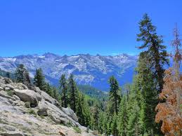 Not an easy trail, especially with the gain in altitude but you cannot beat the views along the way. The hike steepens the last 2 miles to the 11,100′ summit. The last 1/2 miles will require some rock scrambling as well – keep in mind this section is covered in ice/snow most of the year. The trailhead begins in the Wolverton parking area.
- 13.1 miles – Out and back
- 3800′ gain
- Strenuous
17. Acadia Mountain Loop (Acadia National Park)
 Great views of Somes Sound as you hike the namesake of the park. Continue on the St. Sauveur Mountain to make the loop a little longer and see a little more! The trailhead is located off Route 102 to the east side of Echo Lake.
- 3.8 miles – Loop
- 900′ gain
- Strenuous
16. Skyline Loop (Mount Rainier National Park)
 This is one of the most crowded hikes in the park but definitely one that you’re not going to want to miss. The loop isn’t easy by any means but you’ll catch some of the best and closest views of Mount Rainier in the entire park. Along the way you pass Panorama Point, Myrtle Falls, and Sluiskin Falls. The trailhead is located near the entrance to the Jackson Visitor Center at Paradise, marked by stone steps inscribed with a quote by John Muir.
- 5.5 miles – Loop
- 1,700′ gain
- Strenuous
15. Delicate Arch Trail (Arches National Park)
 All of the Utah license plates and pictures don’t do justice to seeing the tremendous Delicate Arch up close. There are easier viewpoint trails if you are not able to hike up to the bowl but this trail is the best of all the hikes in Arches National Park for a reason. On the way, you will pass through desert terrain, climb up slickrock, and make your way along narrow rock ledge before getting to this beauty. Make sure you take the spur trail to the Wolf Ranch Petroglyphs on your way back as well. The trailhead starts from the Wolf Ranch parking area off of Delicate Arch Road.
- 3.0 miles – Out and back
- 500′ gain
- Moderate
14. Harding Icefield Trail (Kenai Fjords National Park)
 This trail rises through a forest to end up above the tree-line with awe-inspiring views of the Harding Icefield. Snow and ice stretch as far as you can see, broken up only by the occasional peak. You will want to check the trail conditions before starting out as it remains snow-covered well into July. Come prepared! The trailhead is found near the Exit Glacier Nature Center.
- 8.2 miles – Out and back
- 3100′ gain
- Strenuous
13. South Rim Loop (Yellowstone National Park)
 This loop combines a few trails but offers some of the best views of the canyon in the park. Beginning near the Uncle Tom’s parking area, travel east towards Clear Lake. After Clear Lake, take a left at the junction toward Lily Pad Lake. You can either start heading back towards Artist’s Point or add another mile and visit Point Sublime for an amazing view! After visiting Point Sublime and Artist’s Point, head back toward the trailhead with amazing views of the Lower Falls along the way.
- 5.0 miles – Loop
- 500′ gain
- Easy
12. Alum Cave Trail (Great Smoky Mountains National Park)
 This is a great hike that has several highlights along the way…you’ll pass Arch Rock, Alum Cave, small waterfalls, and reach Mount Le Conte at the end. The end of the 5+ mile trail meets Rainbow Falls Trail and can be extended into a full day hike if you wish. You could also stay the night at the hike-in only Le Conte Lodge. The trailhead is located off of US-441 S about 9 miles from the Sugarlands Visitor Center.
- 10.5 miles – Out and back
- 2700′ gain
- Strenuous
11. Wheeler Peak Trail (Great Basin National Park)
 Wheeler Peak is the crown jewel of Great Basin National Park and as such this hike is the best of its trails. This summit hike will challenge even those in great shape as it climbs nearly 3000′ to the 13,064′ summit. The trail gets steeper as you get past the timberline and approach the summit. The views from the top are impossible to beat. The Summit Trailhead is a 1/2 mile north of Bristlecone parking lot.
- 8.6 miles – Out and back
- 2900′ gain
- Strenuous
10. Rae Lakes Loop (Kings Canyon National Park)
 I’m going to go against what the title says as this is definitely not a day hike. However, it is easily the best hike in Kings Canyon and one that should not be passed up if you have the time and the ability. Rae Lakes is considered the best backpacking trail in the Sierras showing hikers what this beautiful area of the country has to offer. The trailhead is located at the parking area at the end of CA-180. It is suggested to tackle the loop counterclockwise.
- 41.4 miles – Loop
- 6950′ gain
- Strenuous
9. Mount Healy Overlook Trail (Denali National Park and Preserve)
 This is one of the steepest yet best hikes in Denali if you are able. The trail runs through a spruce forest before breaking the tree-line. The end of the trail isn’t at the summit but to a spot that opens with incredible views of the park to the south. The trailhead is found near the Denali Visitor Center taking Taiga Trail about 1/2 miles before heading northwest.
- 5.4 miles – Out and back
- 1700′ gain
- Strenuous
8. Navajo Loop (Bryce Canyon National Park)
 Bryce Amphitheater is home to some of the best trails in the nation and Navajo Loop is widely considered to be the best hike in the park. The trail travels down into the main amphitheater through ‘Wall Street’ (narrow slot between cliffs). The trail includes amazing views of the popular Thor’s Hammer. Queens Garden, seen below, can be combined with this trail to make a longer, yet easily manageable loop. The trailhead is located in the Sunset Point parking area.
- 1.3 miles – Loop
- 500′ gain
- Moderate
7. Pīpīwai Trail (Haleakalā National Park)
 This top hike has several highlights along the way including a massive banyon tree, a thick bamboo grove, and 400′ tall Waimoku Falls. Hopefully, you will arrive after a recent rainfall so water gushes over the ledge. Either way though, this is one of the best hikes in Haleakalā if not all of Hawaii. The trip to get to the trailhead is almost as rewarding as the trail driving on the curvy and scenic Hana Highway. The parking area is right next to Kipahulu Visitor Center.
- 3.4 miles – Out and back
- 750′ gain
- Moderate
6. Bright Angel Trail (Grand Canyon National Park)
 One of the most popular hikes in Grand Canyon National Park, this trail is a must-do for any hiker out there! Leaving early will allow you to miss most of the crowd as you head your way down from the rim. The views throughout this trail are what make this such a special hike and why it is the best hike in the park. Similar to South Kaibab Trail, there are many locations to turn around. If you are looking for an out and back day hike, consider heading to 3 Mile Resthouse. A trip to Bright Angel Campground and back should not be completed in 1 day. The trailhead can be found just west of Bright Angel Lodge.
- 6.0 miles – Out and back
- 2050′ gain
- Strenuous
5. Emerald Lake Trail (Rocky Mountain National Park)
 Picturesque trail nestled among surrounding peaks including Flattop Mountain, you will pass Nymph Lake and Dream Lake before arriving at the majestic Emerald Lake. All 3 of these pristine mountain lakes culminate the true beauty of the park – be sure to bring your camera! This is an extremely popular area of Rocky Mountain National Park so parking tends to fill up quickly. The trailhead is next to the parking lot near Bear Lake.
- 3.6 miles – Out and back
- 600′ gain
- Moderate
4. Half Dome (Yosemite National Park)
 This is widely known as one of the most dangerous and difficult hikes in the world but if you’re an avid hiker, it is a must-do. A maximum of 300 hikers are allowed each day on the Half Dome Trail beyond the base of the subdome. A preseason lottery is held each March to obtain a permit to hike up the cables. This will take all day so be sure to start early and check sunset times. The best route to the top is via the Mist Trail. The steady climb will lead you to the famous Half Dome cables which allows hikers to ascend the final 400′ without rock climbing equipment. The trailhead is located near the Upper Pines campground.
- 14.7 miles – Out and back
- 4000′ gain
- Strenuous
3. Highline Trail (Glacier National Park)
 The Highline Trail follows the Continental Divide and is thought to be one of the greatest hikes in the US. The scenery, wildlife, ledges, and overlooks make this a bucket list trail for any avid hiker. The best way to get started on this trail is to park at the Loop on Going to the Sun Road and take the free shuttle up to Logan Pass, then hike back to your car. The trailhead is located just north of the Logan Pass Visitor Center.
- 11.7 miles – One way
- 1300′ gain
- Strenuous
2. Paintbrush Divide (Grand Teton National Park)
 This will be one of the best hikes that you will ever experience in your life. Start out early in the morning if you wish to complete this hike in 1 day – permits are required for all overnight backcountry stays. On the trail, hikers will see incredible views of Lake Solitude, Grand Teton, Hidden Falls, and Inspiration Point. The trailhead is located next to the parking area east of String Lake.
- 19.6 miles – Loop
- 4000′ gain
- Strenuous
1. Angels Landing Trail (Zion National Park)
 Not only is this one of the best hikes in Zion National Park but maybe the entire National Park System. The trail is treacherous in spots and not easy to do but it will be in your memory the rest of your life. The last 0.5 mile is what really makes this a special hike as you walk on top of the ridge to outstanding views of the surrounding canyon 500′ below. Only once you reach the summit and witness the beauty that extends before you, will you truly be able to appreciate the majesty of this park. Do not let anyone try to tell you this trail is too crowded or doesn’t live up to the hype, just experience it for yourself. The trailhead begins from the Grotto drop-off on Zion Canyon Scenic Drive.
- 5.4 miles – Out and back
- 1450′ gain
- Strenuous
Don’t forget to stock up on the essentials before you plan your next hiking or camping trip! We have recommendations on:
 Hiking Shoes
Tents
Backpacks
And more! Just click HERE